
I’ll have to start by qualifying that title. Chelsea people have long memories so I should really say streets forgotten by some people. For others the streets demolished in 1969/70 to clear the area for the building of the World’s End Estate will never be forgotten, and for others still the act of demolition never be forgiven. But for those of you who don’t remember, or those who never knew let me just say there was an enclave of streets in the west of Chelsea which no longer exist. This 1935 map shows them and gives you the roll call of streets which have passed into history.

Raasay Street, Bifron Street, Vicat Street, Dartrey Road, Seaton Street, Luna Street – all gone now, and somehow the names themselves are redolent of another time and an older, slightly rougher version of Chelsea. The stub of Blantyre Street lingers on at the edge but you can see that the five (or six) sided shape is now a sunken island among the more familiar names like Edith Grove and Cremorne Road.
Our photographer John Rogers went down there in 1969 and caught those streets in their final transition from a living neighbourhood to an empty shell. You may have seen pictures of some of these streets before. (I did a post on the general history of the World’s End). But this post is purely concerned with the last days of these almost forgotten World’s End streets.

1969. Look at that woman waiting to use the phone. If she could step into 2014 and stand in pretty much the same spot she would see more or less the same buildings. But if she turned around and looked behind her…

She would see St John’s Church and Mission Hall at the intersection of Blantyre Street and Dartrey Road. If she looked to her left and she could see Blantyre Street.

A street full of parked cars which leads tothe last few numbers of Cheyne Walk. (What’s that large one on the right?)
Check the map. You can turn right from Blantrye Street into Seaton Street.

The tree at the end is on the embankment overlooking the houseboats.

In Seaton Street there’s all sorts of semi-erased football graffitti on the wall next to the Chelsea Corner Cupboard including the incomplete inscription Osgood Aven(u)e which must be a reference to Peter Osgood. (“Osgood is God” vied with “Clapton is God” as mottos on the wall back in 1969)
Behind Seaton Street was Luna Street,

where you could still kick a ball down the street if you wanted to. Dartrey Road ran north to south.

Those tower blocks in the distance are on the Battersea side of the river. Running west from Dartrey Road was the oddly named Raasay Street.

Here you can see the first signs of demolition. This is a closer view of the same scene.

Mixed rags and scrap metal still available.
In Bifron Street houses were already vacated.
Some signs of a road closure as a truck gets ready to go. And below, the interior of a house is laid bare.

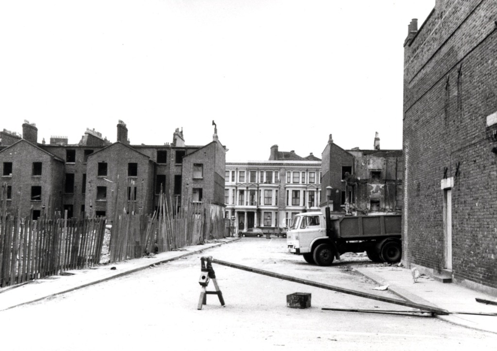
In Vicat Street (Vicat sounds like the name of a dissolute Victorian aristocrat) the process is further along.

You can almost smell the dust rising in this picture and the ones below.

Wallpaper is still visible on the walls of those exposed rooms, and debris in the street.

The empty A F Stokes shop, along with some more unsuccessfully executed football related graffitti. It all looks quite forlorn.
So let’s go back, away from the devastation. If that woman is still in the phone box she can look west and see this view.

Still a little life left in those World’s End streets. The corner of a pre-war car, second hand goods, fish and chips plus whatever they sold at Gandalf’s Garden. All gone, not so very long after these pictures were taken.
Postscript
Don’t think I’m down on the World’s End Estate. I’ve been inside and there are some very nice flats there. And the view is astonishing. I’ve no doubt that living conditions some of the houses in the demolished streets must have been pretty grim. But there is aways a price to be paid for development.


